Tuesday, July 22, 2008

Off Gibralter

Location : Gibralter - 38 37 N 062 46 W
A few days back I had put up a screenshot of Gibralter with my ship a few miles south East of the rock. Here's a picture of the same area of the view from the ship In the background is Spain and at the foot of the rock are a few ships anchored and waiting for orders or bunkers.

Monday, July 21, 2008

Turkey - Classic steamer

Location : The Atlantic - 37 40 N 055 20 W
 
This a a beautiful example of the small steamers that were seen about a century back. Add a couple of paddle wheels at the stern and you could very well be in New Orleans. The thing that puzzles me is that there were no identification marks on the vessel. No name, port of registry of any such thing. The thing looks in great shape, so it might actually be a new building which is being test driven around before the official launch.
 
But please do note the beautiful Wooden superstructure (hell to maintain) and Masts, the midship Engineroom , The L shaped Air ventilator for natural ventilation, Mahagony wooden lifeboats, Extensive halyard design , and ofcourse the gaint wheel at the conning position on the fore of the bridge.
 
One give away that it is a new construction is the presence of the two shankless anchors neatly attached at the ships bow. These anchors did not really become popular with the smaller ships till the middle of the century.
 
But thing is a beauty and it was great to see it in the setting sun.

Saturday, July 19, 2008

Saracena at Skikda

Location - The Atlantic - 36 37 N 043 31 W
 
The picture above is of M.T Saracena with the Algerian port of Skikda in the background. Saracena was ahead of us in line and went alongside to discharge there before us. Small tankers like Saracena criss cross all over the Med carrying small parcels of chemicals or products. One this which we can't see in the picture is that there are two funnels in the vessel, which meant that there are also toe associated engines and propellers. This gives the vessels such as Saracena great manouverability. In the background is the port of Skikda. On the right we see the breakwater and behind it the oil tanks spread all over the countryside. Also in the background are these aweful flares that keep spewing smoke all over the place. The three days that we were there, the town of Skikda was downwind and I can only wonder what they feel about these flares.  
 
I like this particular picture because its got a rough look about it which reflects the real world.

Thursday, July 17, 2008

Turkish Fort

Location - Atlantic : 35 57 N / 028 26 W
 
Now that we have left Europe and Asia behind, I wanted to go back to the main countries that I passed through before coming over here. The one with the best views was of course Turkey with the amazing skyline of Istanbul and the neighboring countryside. This picture is of a fort about five miles north of Istanbul along the straits. Unlike the Indian forts, these forts have a very open feel to them and sometimes go curving into themselves. I can only assume that the purpose of that would be to funnel the attacking army into places where they could be plummeted by rocks, arrows and other such items.

Wednesday, July 16, 2008

Gibralter - view from the top

Location : The Atlantic -
 
After yesterdays postcard of Gibralter, here's another view of the rock. This image of Google earth is used with the same format as that of the image a few days back of my ship in Italy. In this image, my ship is the one on the bottom right. The waters off Gibralter are very deep, with depths going down to over 500 meters just a few miles off the land. As a result, most of the ships have to come quite close to the land to anchor.
 
In the picture above, if you match it with the postcard of yesterday, you can pretty much identify the landmarks. On the right of the rock (East), the three ships bunched close together are vessels anchored, most likely awaiting orders or waiting to bunker. The advantage of anchoring on the East of the rock is that you don't have to pay the port dues. So if you have a ship heading to Gibralter with a long anchorage, you know where to anchor now. :)
 
My ship, on the bottom right was waiting for the anchorage to get vacant in the Gibralter bay so that we could go in and bunker (take fuel). Gibralter bay is on the left of Gibralter and you can see a few ships on the left of the screen.  The Gibralter bay gets very crowded and its not uncommon to hear at odd times of the night, various captains telling other various captians how they have anchored too close to their ships.
 
 Thanks to dad again for sending this picture along.
 

Tuesday, July 15, 2008

Location : Atlantic Ocean - 35 52 N / 015 11 W

From Algeria, we wound up in Gibralter for fuel. Sadly as events would have
it, by the time we dropped anchor, it was late at night and we left by dawn.
This meant that this was the second time that I had anchored at Gibralter
and couldn't see the rock. If you have found yourself in a somewhat similar
situation, you would appreciate the postcard above that the Agent sourced
for me. If you can't make out the markings properly, the things of interest,
seen in a clockwise direction from top left are :
-Cable Car
- Apes Den
- Catalan Bay
- Botanic Gardens
- Saint Michaels Cave
- Europa Mosque
- Shrine of our lady of Europe
- Europa point
- 100 ton gun
- The convent
- Cathedral of the holt trinity
- Line wall synagouge
- Cathedral of Saint Mary the crowned
- Marina Bay
- Land Frontier
- Great Seige tunnel
- Moorish Castle

This does let you know pretty much everything that a tour guide would tell
you over six hours and a hundred pounds. And as far as you are concenred,
another thousand pounds of air tickets. :)

Saturday, July 12, 2008

Ile Srigina

Location -
 
 
Ile Srigina is sort of place where I imagine a woman in long flowing white dress, to face into the wind, looking far away at the horizon into the setting sun. The camera, possibly on an helicopter, moves around, panning the scenery, a few waves crash into the rock below and the sun sets, bringing in the credits of the film. 
 
The British Admilarity takes a dimmer view of the island and describes the setting as a lighthouse, 54 meters high white square tower.  As additional helpful tips, it adds that the light is obscured by Point Esrah when bearing less then 122 degrees.
 
I was anchored for two days about a mile and half from this island and loved it for all that time. The sun sets rbehind the clifss in the background and the whole setting looks etheral. Though its a bitch to catch on camera!


Thursday, July 10, 2008

Flares

Location - Algeria
 
Came into the port the other day and since they don't allow anybody off the ship, it is only a limited view of the country we get. FLares light up the night sky in the port. The weather is fine with a dry northwesterly blowling. This thankfully means that the smoke form the above flares drifts away from us. 
 
So se sit on the stairs leading to the bridge, side by side, looking at the flames leaping and jumping - Struggling to get out of their perch.  

Tuesday, July 08, 2008

The bulk carrier Lepetane

Location - At Anchor off Algeria   
 
So here we are anchored off the Algerian coastline. Pictured above is the bulk carrier called Lepetane who seems to be waiting for her turn to berth and discharge her cargo. The port seems rather full so I don't think they are going anywhere in a hurry.
 
In the background is another small coaster that seems to be shuttling between the Algerian ports And further back is the rugged Algerian coastline.

Sunday, July 06, 2008

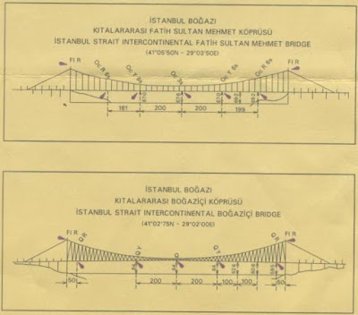
The bridges of Istanbul Bogazi

Location : Off Sardegna Island, Mediterian / 38 45 N / 005 23 E

Yesterday I had shown you a picture of one of the bridges connecting the
continents of Europe and Asia. To the bridge enthusiasts, who might find the
pictures of the bridges often enough, I wanted to show this information
about the bridges, given on the navigational charts. These are great bridges
and as we can see that the first bridge has a span of about 600 meters, the
second bridge, goes on for about a kilometer.

With a height of about 68 meters from the high water mark, these are some of
the greatest bridges that I have passed under.

Saturday, July 05, 2008

The Bridge at Istanbul

Location : 150 miles off Sardegna Islands, 38 50 N , 005 43 E
 
Readers of my blog will remember the Bridge of the Americas at Panama City , that connected the continents of North & South America.
 
Pictured here is one of the two bridges at Istanbul, Turkey. These bridges are the only road (and probably rail) connection between the continents of Europe and Asia. I did mention on my previous post that they are building an underground/water tunnel, but I think that is still some years away from opening.


Wednesday, July 02, 2008

Istanbul

Location - 40 28 N / 006 32 E - Off Sardegna
 
This is another view of istanbul at dusk.