Tuesday, October 30, 2007

The Copus Christi Inner Harbor bridge

Location - Yucatan Channel - 22 07 N,085 54 W

This is the Corpus Christi inner harbour bridge & if you look a few post back to the bridge of the Americas, you'll realise that it bears a striking resemblance to the bridge of the Americas in Panama. I'm not sure which bridge was inspired by whom , but surely it's more then a plain coincidence.

As we had come to the port at night, this is the snap of us going out. On the left of the bridge is the Texas State Aquarium, where we went and saw a nice dolphin show. On the right of the bridge is a Museum (I think of fine arts. Which we did not go to. I think our priorities are very clear. :)

Though the bridge might look like the Bridge of the Americas it is no where near in size. The bridge has a horizontal span of 300 Feet and a vertical span of 138 feet. When we came in, we had an air draft of 132 feet and as we passed under the bridge,I was convinced that I had come out on the other side minus a radar antennae.


Monday, October 29, 2007

Corpus Christi - Texas

Location : Gulf Of Mexico - 24 06 N, 089 26 W,

I have been off the blog for the last few days and the reason for that was that we were in the port of Corpus Christi, Texas. Though its not a port you hear of often, it did rank as the sixth busiest port in USA. As the outbound pilot explained to me,
the ranking is done on the basis of the deadweight handled by the port. Corpus christi, with more then 42 feet of water is one of the deepest ports in the US and thus handles bigger ships and so manages to climb up on the charts.

But regardless of the number of ships that the port might handle, my berth could not have handled too many ships. It took us almost five days to load a cargo of about 37,000 MT. The picture above shows the jettey where we were tied up for the duration of the stay.


Monday, October 22, 2007

Arrived Texas

Location : At Anchor off Galveston

We came in and dropped anchor off the coast and I must offer my condolences to all Texans. This coastline is some of the most unexciting coastline in the whole of the US. I have been up and down the coast of this magnificent country many times, and the
Texas coastline always seems to me, the most boring part of the country.

And coming from a place like Panama, it really looks fore lone and barren. The only thing visible are some smoke stacks of a few refineries & a few people out fishing in small dinghies on a weekend.

More in an effort to cheer myself, I'll show you what I was seeing four days back. As the moisture laden wind rises just a hundred feet, you could literally see the clouds being formed out in Panama.


Saturday, October 20, 2007

Sunrise

Location : Gulf of Mexico - 24 50 N , 090 46 W

People do ask me if I don't get bored looking out the at sea for months & months. Its hard to explain that the sea never looks the same even during the same day. The other day, I woke up & opened the curtains of my porthole to look at this.

Even after so many years, some of the sights that the sea throws my way are still breathtaking.


Friday, October 19, 2007

twenty one hotel

Location: Gulf of Mexico : 22 25 N, 086 19 W

I think I mentioned that each ship transiting the canal is given a number for that day. All ships going south bound (from the Atlantic to the pacific) are given even numbers. When we were going to Chile, we were "Eight". If for some reason you get
stuck in the middle of the canal, the next day, to avoid any confusion, you are called "Eight Alpha". The last time we crossed, we had to anchor in the Gatun lake for two days. That got us the exalted title of "Eight Alpha Alpha".

The day before we were "Twenty one".

The flags in the picture are the numeral pendants "Two" & "One". The bottom most flag is the Hotel flag I had spoken about earlier that signifies that the Pilot is on board the vessel.

Northbound vessels that are delayed are called "Bravo"'s.


By the sea

Location : Carribian - 20 19 N, 083 59 W

This is the latest work by Puja & its called by the sea. This was the biggest canvas that she had attempted. She has now picked up a pretty challanging painting & I think it'll keep her busy for the better part of a week & half.


Thursday, October 18, 2007

Panama City

Location : The Carribians - 18 19 N, 081 49 W

We crossed the Canal yesterday & are now on the way to Texas.

Pictured above is the Panama City outline as seen from the Pacific anchorage. It seems to be huge city, but I'm informed that it is pretty much the only city in the whole nation.

This is pretty much the way we see you from our ships. :)


Tuesday, October 16, 2007

The Clouds of Panama

Panama - Pacific Anchorage

The clouds were out in full force yesterday. There is hardly any wind out here & the clouds lazily sweep the countryside & the sea, with heavy rain. The Mountains themselves look a little small infront of the clouds. Comparing the ships to the clouds
seems a far stretch indeed.


Panama

Location : Pacific Anchorage, Panama

Today finds me again at Panama. We came into the Pacific anchorage & have dropped anchor about two miles from the sea Buoy. The place remains beautiful as ever with clouds hugging the hills & the rain coming & going.

Pictured above is not the anchorage, but a picture from the Gatun Lake. The red tanker is a product tanker from the Aurora lines. to the right of the tanker, you can see the Gatun Dam in the background. That is the dam holding all the water of the
Panama Canal. & to the very right of the picture is one of the Maersk line ships.


Friday, October 12, 2007

Flowers

Peru Coast - 07 20 S, 080 50 W

The spring is starting in Chile right now & the flowers are blossoming everywhere on the countryside.

As I was going along the sea coast, the person kind enough to give me a ride to the town was explaining that the cold current along the chile coast caused a fog in the mornings. In the north of Chile, where it was desert & absolutely barren, this fog
was enough for the flowers. As per him, if you went to the northern deserts in the month of Oct, you would find a blanket of flowers over the sand dunes as far as you could see.

An amazing sight that must be. :)


Thursday, October 11, 2007

Tectonic plates & Geostacy

Location: Peru Coast - 13 07 S, 078 53 W

Today lets leave the mundane topics of the Sea & talk about interesting things such as Tectonic plate movements. The "Tectonic plate theory" is a generally well accepted theory these days. What that means, is that enough people oppose the theory so
that no one dares to call it the "Tectonic plate fact". :)

In basic terms what it implies is that the Earths core is made of molten magma & the continents are in effect floating pieces of solids. Much like wood floating on water. The Theory of Geostacy proposes that like the wood or ship floating on the water,
the continents float with respect to their weight. If you add more weight to them, they will sink & if you remove weight from them, they will rise. A great example of this are the poles. It is estimated that due to the melting of the Ice caps, so much
weight will be released from the landmass that the whole continent will life up by many centimeters. This is known as Geostacy. So if you thought that the rivers would eventually level the continents to the sea, you're mistaken. The continents will
simply rise up every time the river cuts it down.

Much like the floating pieces of wood in a pond, the tectonic plates are also in motion. And as these plates meet, some of the most exciting things in geology take place. The fact that these "most interesting things" take a million years to show any
effect at all, should not dissuade young readers from the inclination to take up geology.

There are two things that happen when the plates meet. Either they both buckle & go up & form mountains such as the Himalayas, or they go down. This is where we come to Chile & Peru. Out here, on the west coast of America, you have the two plates
moving towards each other and they actually go down. This is the reason why just about 30 miles of the coast of South america, you can find depths as much as 8000 meters. Practically speaking, its as close to a straight drop as can be found anywhere on
Earth. It also means that if you come to chile & drop your key on a fishing trip, you better break your hotel door.

But something interesting happens when these two plates go down. Subjected to the immense pressures as the they go down, they actually turn into magma (liquid rock) & then finding fissures in the South American continental crust, come up in huge
gushing volcanoes. This is the reason why just fifty miles inland on the west coast of South America you find great many mountains & active volcanoes.

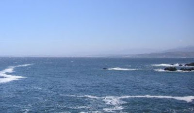
I had taken the picture above standing on a sea side road close to a town called Vina Del Mar. You can see the mountains in the background which must be hardly 30 miles away. And thirty miles on the other side, you have some of the deepest parts of the
Oceans.

These are great areas to be around if you like these sorts of things. And if you keep dropping stuff all the time, then you're better off at home.


Wednesday, October 10, 2007

Still life

Location :- Peru Coast 18 24 S, 077 02 W

This is the latest of Puja's paintings and I think its simply great.


Tuesday, October 09, 2007

Far far away

Location : Chile coast - 27 26 S / 073 43 W

Puja , being the prodigious painter that she is, has now completed three paintings. The first one that I showed you, was actually her second painting. This is actually her first painting. It's titled "far far away".


Sunday, October 07, 2007

Chile

Location : Valparaiso, Chile

This is a beautiful Country. Everyone on the streets is kissing one another & gorping one another. Apart from that the country side is nice too. This is the view from the jetty on which our ship is tied up. It is a beautiful beach and once the sun is
up, you can see people soaking in the sun. The temperatures here are pretty low & once the sun comes up, everyone is out on the beach. People drive beach bikes & horses on the sand & you even see people surf boarding on the waves once they pick up a
bit in the afternoons.

There are of course women in bikini as well & I'm afraid that my duty officers might actually have their binoculars trained somewhere other then on the ships deck. I wish people would be more disciplined these days & simply go and take pictures of the
beach to blow up & see on their computers.


Friday, October 05, 2007

Panama Birds

Location - Chile

Well we arrived at Chile and things are a bit hectic. Just wanted to leave you with a picture of a bird from Panama. In the docks, an extensive grid of Cameras is used to monitor all happenings. These cameras also provide a useful perch for the local
birds to sit & spot out their next meal. In my transit, I often saw different birds use this camera for sitting purposes when they could have sat anywhere nearby.

Something to do with an birds eyeview I guess. :)


Thursday, October 04, 2007

Shadows by Puja

Location - Chile Coast 29 00 S, 073 05 W

Puja has brought along her painting kit with her & was busy the last few days with the Oil paints. Presented above is her first effort at a nude.

We call it Shadows. :)


Wednesday, October 03, 2007

Leading lights & channel Navigation

Location :Chile Coast - 27 48 S, 073 34 W

I wanted to talk about the navigation in confined waters today. Navigation by itself is a very tricky thing. The basic purpose of Navigation to find out "where you are" & as a derivative second step, "where you are going". In the open sea, the beauty of Navigation as an art worked upon over the thousands of years becomes highlighted. To me, there are few things more beautiful then the act of setting down in paper, your position within a mile on the chart, using a star many many light years away.

But lets discuss ocean navigation some other time. Today as the topic suggests, we shall deal with Inland navigation. One might reason that with a sign board every 50 meters, it would be easy to figure out where you are. And I would have to agree. Inland navigation is not really about "Where you are going", but about "How you are getting there safely". Due to the restricted waters of Canals & channels, it becomes critical to keep ships in very predefined routes & ensure that they don't go off the axis by more then a few meters. When you are dealing with ships around 200 meters in length displacing more then 50,000 MT of water, this calls for some expert handling & all the help that you can get.

Navigation in inland waters is usually done in Rivers and channels. The easiest way to mark these is by the placing of Buoys. I think I had spoken about the IALA buoyage system some posts back. In the Panama canal, if you are on the southbound transit , you keep the Green buoys to your Port.In the picture above you can see the canal marked by Buoys. This is a fairly typical layout of the canal & there are an amazing number of bouys per mile in the Panama Canal. At night, a straight stretch of the Canal actually reminds you of a runway lit up at night with the landing lights.

Apart from the Buoys, another Navigational aid of much importance, especially when the channel is not very well marked, is the use of the Leading lights. These lights are shown in the second picture as I'm not sure you can see them well in the first.
Simply said, if these lights are in a straight line when you see them from the bridge, it would mean that you are in the middle of the Channel. If they are not aligned, you simply apply set in the appropriate direction till you come back to the middle of the channel. In the picture above, you can see that I am a little to the starboard of the centreline, but that was because we were making way for the other vessel in the picture to pass by.

unlike Aeroplanes, only one ship at a time can remain in the middle of the channel. :)


Tuesday, October 02, 2007

Comment on the comments

Location : Chile Coast -20 34 S, 076 14 W

Just wanted to come by & say that even though I can't comment on the comments page because I'm not connected, I do read them & appreciate them. Thanks for the comment Mieke on the seagulls. I might just take a picture of the port fwd deck that these
little buggers have decorated with their poop. I fail to understand how these chaps can eat so much. I am afraid I belong to those few who have not read J Seagull. It is on my "to do" list and I promise that I will get around to it.

And thanks to Anon who pointed out that the white buildings in the pictures of the Panama locks are actually the control towers from which they operate the lock gates & the valves. The beauty of the Panama canal locks is that there are no pumps
involved. The lake (and the full Panama Canal) is above sea level. So what happens when the ship comes in the lower lock is that the valves between the two locks are opened & the water simply flows down with the force of Gravity. It is a beautiful
system & apparently the valves & the lock gates are the same as were in operation way back in 1913.

The down side of this method of operation is that everytime a ship comes up & then goes down from the Panama Canal, freshwater is lost out into the Atlantic or the Pacific Ocean. The water is regained by rainfall. In the ongoing expansion of the Canal,
they are planning on building bigger locks that will actually use less water. They plan on doing this by using some reserve pools. Plus they will be increasing the height of the Gatun lake by a few feet. But not everyone is happy about it & I'll have
to do a bit of reading up on the modalities of it when I get back.


Monday, October 01, 2007

Miraflores Locks - Panama

Location : Chile Coast - 18 45 S, 076 54 W

The picture above is one of the classic shot of the Panama canal. A gem of a shot if I might be allowed a little modesty.

Let me explain. Of the three lock gates of Gatun, Perdo Miguel & Miraflores, it is the Miraflores that is the most famous. This is simply because it is the closest to Panama city, & so has a big tourist centre. Hence, if a chap staggers over to you in
a pub on Grant road at noon (Lets skip what you were doing there for the time being) and claims to have visited the Panama Canal, he is in most probability, talking of the Miraflores.

Of the Miraflores, the White Building featured above is the most famous landmark. It stands, as it stood way back in 1913 when the canal opened up & no one is quite sure what it is used for these days. If you zoom into this low resolution picture, you
might just make out the writing on the wall "Miraflores Locks 1913"

So the picture has the following going for it:
01. The Miraflores locks
02. The Building of the locks
03. A great profile of the Locomotive - The work horses of Panama
04. A container ship inside the adjacent lock.
05. A view of the entire lock & the lock gate on the right.

Yes.An absolute classic. Now if only that funnel of mine has stayed out of the way...