Saturday, December 27, 2008

The prognosis

The last few days haven't been good to us. Apart from the way things have
turned out on the ship, the weather's been doing its bit keeping us in a
gloomy mood. Todays weather report shows another cold front (the curved
lines with spikes) swooping down on the Texas coast, bringing with it,
another spell of fog, cold, showers and squally weather.

I guess the only thing to do is to batten down the hatches, turn into the
wind and ride out the winds.

Saturday, December 20, 2008

Seabulk energy at Gaveston anchorage


Things are looking up today. The sun has come out and the fog seems to be dissipating. I can now actually see the mast and funnel of “Seabulk Energy” a mile off as the sun works on this fog from the top down. As I came down from the bridge, the pilots were opening up the Houston Ship channel and taking in the ships in.


I would be lying if I said that we weren’t enjoying the anchorage. But the problem with anchorages is that you can’t make fresh water and your provisions start running out. So it will be great if things start moving up in the channel and we can get some fresh veggies on our plates.


Friday, December 19, 2008

Cold, foggy and spanky in Houston !!

As might have been guessed, I am back on the ship and back in the same part
of the world, the US gulf. It's a part of the world that I am beginning to
like. The US gulf is a rather dull place. And dull things are something that
I am beginning to relish these days as a Captain. I go to ports I've been
to, I meet pilots I've met, I dock at berths I've docked at and even the CBP
(Customs and border patrol) personnel have begun to recognize me (heaven
forbid!).

So all in all it was a rude surprise when I came in to Galveston fairway
anchorage and met a wall of fog that everything more then 20 meters into
blankness. Fog is something god made strictly so that like minded people
could frolic in it over sloping hills and unending meadows. It was not made
to roll over into the sea and terrify you with fog horns blaring out at you
from all seeming directions. And it most certainly was not meant to be
rolling out over the US Gulf. Everyone seemed to be as disoriented as this
supply boat by the name of "Spanky" was going up and down the anchorage till
panicked duty officers would call out to it and warn of impending
collisions. Undetered, Sapnky would simply alter her course and go headlong
into the next ship that came up. Keeping as large an discance as I could
from that fellow and another madcap fishing vessel called Sea Angle, I
dropped anchor as early as I legally could.

The local weather reports are actually forcasting a worse cold front coming
down and freezing water pipes around the Houston greater area.

I do not like cold. I don't like fog and I don't think I like Spanky much
either.

Thursday, October 16, 2008

Party time


Its an occasion for celebration and joy. I have signed off from my ship and its back to home for me. Years back, when contracts were longer and booze available, it would have been a pretty good excuse for a party like the above. Typically the mate would raise the topic of a farewell get-together with the old man over breakfast and instructions would be given to the catering department to get things ready. The crew would then meet in orderly groups at the pre-assigned time and talk urbanely about wide ranging pertinent topics such as the changing cup sizes of Pamela Anderson. The "get-together", would then steadily go downhill till the old man left for his cabin, after which people would be often be spotted in poses like the above, gyrating to lyrics of some pubescent girl , claiming to be a "Barbie Girl". This would go on till enough people were escorted to their cabins drunk, or the scene looked too gay for even seamen like us!

I'm not sure if I'm actually sad that these parties don't happen any longer. Now that I'm the old man, I realize that the poor sod might have been going off to his cabin, probably to offer a long prayer and prop himself at the porthole to keep a lookout for the rest of the night.

What I feet sad about is that I no longer have a twinge of sadness leaving behind friends with whom I have shared my life with so intensely for such long months. Instead there is only a sense of relief that the contract went off safely and without incidents / detentions / observations / accidents. What I feel sad is that the chap seeing me off at the Gangway isn't really thinking of me as he says his byes, but is probably offering a prayer that his contract goes off the same way.

Thursday, October 09, 2008

Two balls and a diamond in between

We mariners have a nasty reputation of being perverts. Now we of coures have worked hard at deserving it so its not be be thrown away lightly. Which is why we keep hanging our balls out for all to see. Hanging from the halyards we see something called very imaginatively as  "shapes".

These shapes are used as required by the collision regulations to indicate that the vessel is "Restricted in her ability to Manouver" or "RAM". As I have been spending most of my evenings in the US gulf doing lightering operations. As a master, it feels inherently bad to wear these shapes on my halyards, because it means that I can't take my ships anyway I want to. Adn when your 200 meters plus vessel is manouvering at distances of 20 meters from a 300 meters long ship, the last this you want to do is go any closer. I find the manouvering for this fascinating because the dynamics of working such large vessels is amazing to watch unfold. Maybe we'll have beer one day and I'll explain the hydrodynamics on paper napkins.

In the meanwhile, observe the balls.


Wednesday, October 08, 2008

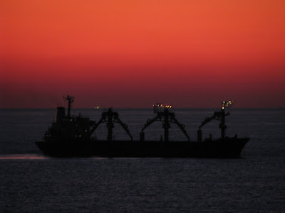
Sunset on the ship


 Now that its time to go back home, US Gulf seems to be saying goodbyes, by offering me stunning views. As I was doing my last lightering operation, we had a stunning display of colors on the horizon spread over the vista of smouldering oil rigs and installations.

 And a great good bye surprise - I shall be going up the beautiful Mississippi forone last time and signing off at New orleans. I haven't been to that city in a few years, so it'll be good to walk those streets.


Tuesday, October 07, 2008

Last of the bad guys - Marco

 
Tropical depression 13, has been thought worthy of a name and has been upgraded to Tropical storm  "Marco ".  Its been a tough year for the people of this part of the world, and even caused a few ulcers and sleepless nights to me and my pretty ship.
After being banged around by both Gustav and Ike, I am glad that the season is drawing to a close and hopefully Marco will be the last of the bad guys we see this year.

I should anyway be out of this area and back home, but I hope you all stay safe here.

Birds on a wire


A short post today. The picture above was taken at Pascagoula. Sights like these are quite common, but they always remind me of home where you'd see birds sitting on an electirc wire.

Included in the picuture from the bottom to top, is our ships crane, with the Markings SWL 15T, which refers to the safe works load, a smaller fendering davit, light post air pipes and bollards.

Saturday, October 04, 2008

The Dredger - Glenn Edwards


The type of support vessels that come next in line to the Tugs in my "List if favotrite vessels" are the Dredgers. Pictured above is the Dredger Glenn Edwards, pictured above at the mouth of the Pascagouls Ship Channel in the Mississippi state. The Glenn Edwards was waiting for us to pass so that they could continue with their dredging works.

Glenn Edwards is a relatively new ship, floated in 2006 near here in Mobile Alabama. You can see a very informative article about it here at the workboat.com website. In it we are told of the extremely high standards of specifications that the vessel is built to.

The method of operation of dredgers like the Glenn Edwards are simple in principle. The boom that you see on the sides lower to the sea bed and act like a gaint Vaccume Cleaner, sucking in all manners of mud, small rocks and debries. These are deposited in the middle of the ship in their hold, from where the water is simply drained out. The dredger then makes its way to the dumping ground, where the bottom of the hold simply opens out, letting the whole of the load simply drop down.

Because the US coast is blessed with deep rivers and waterways, it is hard to spot too many of these vessels around here, but at the mouth of the Mississippi and in the channels of the US Gulf coast, these chaps keep digging away to allow people like us transit without too much heartburn.

Leaving the Mississippi


I'm leaving the Mississippi river today. Though I spent quite some time on this river during this voyage, thanks to some very slow loading, I do feel bad about getting out of here. In contrast to the whole of the US gulf, the Mississippi river is a beautiful place to be in. And in this time of the year, the dawns and dusks are serene. The river gently flows by and all manners of crafts make their way on it with grim determination.

Its immpossible to concieve that any type of music other then Jazz could have been born on the banks of this river.

Friday, October 03, 2008

Ship art on the Stena Poseidon


Its rare to see art or anything resembling it on the sides of Merchant ships.  So it was a treat to see what Stena Ice have done with their ships. I saw the Stena Poseidon in the Mississippi river where I assume she was loading cargo. From news reports on the net, the Poseidon, along with her sister ship, the Stena Palva, have been chartered for a period of 10 years to Neste oil, on a route from Finland to US carrying Low sulphur fuel oils. She is a new double hulled tanker (2007 Croatian built), that is actually registered in Finland currently.
 
  
 The Stena Poseidon seems to be of a fleet of ships of the Stenabulk that is certified for ice class. ABS has given the Poseidon the A1 class. You can check here on Wiki to get the basic outlay on Ice class ships. Also if you need to know some more about Ice Class ships and shipping in the cold, you really must have a look at this excellent paper written by Capt Duggal for the Nautical Institute .


This is how the the whole of the ship looks like, and you will admit that the whole effect looks rather pleasing. The picture of the polar bear looks neat and who knows - it might even have been designed as a deterrent to the Pirates! 
  
Links : Ship-Technology , bnet

Thursday, October 02, 2008

Mississippi River


The Mississippi is a fabulous river. There is absolutely no question about that. It has been a few years since I came this way, and I really relish the opportunity to sail on it again. These are the same waters over which distinguished people like Mark Twain actually piloted ships.

It is common Knowledge that Mark Twain actually selected that pen name because in his days of piloting the Mississippi, two fathoms was the established safe depth of water. So seamen would mark two fathoms ( mark Twain) with their lead to establish safe navigation.

In the picture above, you can see a tug pushing a few barges of coal down river. In the picture is the Cantilever bridge for New Orleans. and to the right of the picture, you can actually see a bit of the New Orleans city.

Along with the Mississippi, Bhramaputra, Ganga and the Nile, I have sailed, boated, immersed myself or atleast seen almost all the major rivers in the world. The only one I have yet to go up is the Amazon. Maybe later.

The evenings are spent looking at the gentle flow of the river as is passes us by and the easy flow of traffic along its waters. Its hard not to wonder how lucky America is to be blessed with such wide and bountiful lands and waters.

Wednesday, October 01, 2008

Sunset off Mississippi Delta


The days are fully packed these days. The fact is that I am preparing th get off the ship and this means not only extra work to get things in shape for next guy, but also a lethargic attitude in getting to posting long blogs. 
  
So  till the time I get off, I think I'll focus on smaller posts for the time being. This above picture was taken during a stunning sunset off the Mississippi Delta. Its rare to see ships of this vintage and with derricks such as these. 


Saturday, September 20, 2008

Sorrounded by Sharks


As we lay anchored off Pascagoula, we were surrounded by Sharks. These were young ones and were only about a feet plus in length. Its rather rare to see these creatures out at sea, because unlike Dolphins and Whales, these don't come out of the water and so are very hard to spot from a moving cargo ship.


But luckily as we were at anchor and the water was very clear, we could spot these chaps as they swam all around us. As you can see there were many of them all around and I manged to count as many as 14 of them at a time. As far as I can Identify, they seem to be the Atlantic Sharpnose Shark, which is also found in good numbers in the Gulf of Mexico.


I read out here that a huge gathering of whale sharks are taking place off the coast of Mississippi and Louisiana. Since I am around these waters, it would be really neat to get a sight of these chaps as well.

Links : Sharks In Wiki, Shark Species ,

Thursday, September 18, 2008

Fishing Vessel " Angie baby"


The above picture was taken on a beautiful day at Freeport, Texas, when my ship had gone there. By habit, I put everyone of such vessels that catch fish as fishing vessels. Out here in the US Gulf, they are called the "Shrimp boats".

The Angie Baby pictured above was trawling in the waters of the inner channel and the dog on the deck was exibiting a calm detachment that would have made any dog proud.

When I think of shrimp boats, I am invariably reminded of "Forrest Gump" and his shrimp boat. As a matter of trivia, reported on this website, the shrimp boat used in that movie is moored in the moat at Planet Hollywood restaurant in Disneyworld resort in Florida.

The above picture was ofcourse taken before either hurricanes Gustav and Ike. As I write this, the port of Freeport is closed and most of the Nav aids to the port have been washed out.  Boats that small can't head out to sea like us to ride out the storm, and are rather at the mercy of the tidal surge and winds. I can only hope that Angie Baby fared well.

Monday, September 15, 2008

USCG 559


Everytime a hurricane comes out, it screws up everything out at sea as well as the damage it does out on the land. During the hurricane Gustav that passed through a few days back, all the approach channel buoys of the port of Pascagoula were washed off. These buoys are anchored to the sea bed and can be dragged off position in strong winds and swell.
 
It is the job of ships like the above US coastguard vessel to get those buoys back in place. You can see a couple of buoys lying on their decks, which they were probably carrying incase a few of the buoys might have been lost.
 
These guys did a stellar job in getting things moving when Gustav passed through and they are going just as good a job now that Ike has gone by.

Friday, September 12, 2008

NOAA Vessel Pisces at Pascagoula


Few mariners on the US coast will have anything disparaging to say about the NOAA. I have always been a fan of the organization, and am especially grateful to them for the invaluable assistance they give us during the current situations such as the Hurricanes. So I was especially pleased to spot on the horizon, a ship with the markings of the NOAA. A couple of posts back, I had put up a picture of an oil platform in the US gulf. The picture above is of the research vessel, "Pisces" as it is passing that same oil platform.

The Pisces was launched on 19th Dec 2007, and if the launch page is to be believed, she was going to begin operations in Late of 2008. So it is quite possible that I captured her on one of her first voyages out to sea. Do look at the video of the launch that I found on Youtube, which is amazing to watch.


The Pisces is one of the four ships to be launched in Pascagoula that is supposed to be a quite ship, which improves the research facilities. Another neat gadget on the NOAA website is the Ship tracker page, which lets us track all of the NOAA ships. Sadly they haven't uploaded the Pisces details on the website yet, so we can't see her on the map.

Source & Links : NOAA on Wiki , http://en.wikipedia.org/wiki/NOAA

Big Bad Ike


"Big bad Ike" is what the media in US is calling the lastest hurricane to hit their shores. After dubbing Gustav as the mother of all storms, one would have thought that the granny wouldn't show up the next week, but that is pretty much what has turned out to be.
 
The problem with Ike is that even though it is still a force 2 Hurrican, it is one monstrous system. If you look at satellite picture of Ike, you will see it witha footprint all over the US gulf. When we got Gustav a few days back, the gale force winds were forcasted within a distance of 160 miles from the eye. With Ike, the figure is 250 miles, which is actually 500 Km. Our ship is atpresent more then 300 miles form the eye, but we are bobbing around worse than a cork in a bathtub.
 
But then there are worse places we could be right now. At the storm centre, there are actually waves of 35 feet rising up as we speak. Picture six storied buildings crashing all around you.
 

Seagulls

.
 
Right now I am hanging on to my ship as we are being banged around by Ike, so this is a good time to remember the good weather gone by and yet to come. The above picture is from the Port of Pascagoula when an unusually large number of Seagulls were foraging around in the wake of the ship. Its usual to see these trailing behind trawlers as they scoure the waters, but seeing them swooping around our stern was a welcome change.


Wednesday, September 10, 2008

Stolt Concept at Freeport

I had put up a post about Freeport, Texas and the way it was a sleepy little town. This place really is one of the biggest thing going for the town. Pictured above is the Stolt Concept, moored at the Jetty of the Dow Chemical plant at Freeport.
  
I haven't personallt sailed in Chemical tankers myself, but the ship above is as big as a chemical carrier is going to get. The Concept is 177 m long and has a beam of 31 m. The Ship was built in 1999 and operated under the Liberian flag untill 2000.
  
As I said earlier, the complex of piping in the background is the Dow chemical plant. The pilo told me that when he had first started working at Freeport, a total of forty thousand people used to enter the gates of this chemical plant everyday. The number sadly has decreased to about nine thousand these days. 
 

Absolutely Unrelated and irrelevant Titbit - Dow Chemical was the sole supplier of Napalm to the US Military during the Vietnam war.


Tuesday, September 09, 2008

Ike is here


.
I think the one thing that is stopping people from talking too much about Ike is figuring out how to pronounce it. But seriously, with one hurricane following another, one gets tired of the whole show. The season has barely started and we are on to the 9th hurricane and now we are already hearing of the Josephine following Ike. And the scary thing is that the season actually ends in October.


Well anyway, Ike enters the US gulf sometime later in the night, and is expected to make land-fall sometime over the weekend in Texas or near the Mexican border. Thankfully I should be floating around far away from the path of Ike to not be bothered too much.  Will keep you all updated.

Saturday, September 06, 2008

Oil Platforms

.
.
The US coast all along the GUlf of Mexico is dotted with oil Platforms and installations that pump oil back to the shore along a vast grid of underwater pipeline network. Pictured above is one of the bigger oil platforms to be seen out here.
.
As you can see out here, on the left of  the platform is the accomdation space and also visible if the Lifeboat for emergencies. When Gustav came, platforms like these were evacuated and are now coming back to normal status.  Also at the foot of the left pylon is a Supply boat. These supply boats are the work horses of the US Gulf and supply everything from stores to people to these rigs.  

Sunday, August 31, 2008

Gustav - The sleep depriving giant

.
Location : US Gulf
.
It is surprising how Gustav seems to have filled up the whole of Gulf of Mexico. It sure is tough to get any sleep out here when this fellow is stomping all over the place.
.

Gustav - A determined Cuban

Location : US Gulf
.
When you look at the cloud cover over the entire Earth, the hurricanes heading towards me seem rather small. Gustav is turning out to be one Determined Cuban on his way to the US. He leaves the Cuban Coast tonight and is forcasted to make Landfall on the Mississippi Delta sometime early on the 1st PM. Since we were pretty much on its way, we are running with all our speed. Lets just hope that the forcasters know what they are talking about. If this Cuban decides to join his cousins in Florida, its going to spoil a lot of dinners out here!
.

Saturday, August 30, 2008

Helicopter landings


Location : The US Gulf

The other day we had a helicopter land on the vessels heli deck. In the US Gulf, since its too cumbersome to send surveyors and charterers rep by launch for the Ship to ship ops, they usually fly them out of New Orleans. As the mothership was actually smaller then us and didn't have a Heli-deck, the chopper came over to us.

A nice change from the ordinary. I had flown in one of these choppers a few years back and it was a wonderful feeling. Please note the small floats on the bottom stands of the chopper. As the pilot then had explained to me, "They make the chopper sink slower in case we ditch this baby."

Gustav & Hanna - The Hurricane map

Location : US Gulf Coast
From where I'm sitting, this is one uncomfortable picture.  The above satellite imagery shows the whole of the US gulf and Atlantic area. The One on tip of Cuba is Gustav and more to the east is Hanna. Hanna is projected to die down a bit to "Tropical Storm" status over the next few days, but Gustav is slated to hit the Louisiana coast on the 1st PM or 2nd PM. Which should make my life uncomfortable sometime late on the 30th.

Friday, August 29, 2008

Freeport and the Baptist church


Location : The US Gulf

when I heard for the first time that we were bound for Freeport, I had wild thoughts of waterskying in the Bahamas. Turns out that there is a Freeport in Texas as well. Its not somethig that really appeals at first glance. Searching for places of intrest only reveals one beach out there over which surf breaks only when hit by a grade three cyclone. which is coming by the way. But unless the high winds start blowing them away, the place is being ruled by huge gangs of Mosquitoes. I read in a Louis Lamour book that mosquitoes in Texas can actually kill a horse. The author might have been thinking of Freeport when he wrote that.

But then this post is not about freeport, but about Religion. With every post I try to learn something new and for this post I am going to read something about the Baptist Church. The reason I'm reading up on the Baptist structure is because of the Seaman's centre that really is one of the best things going for the town. The places is filled with dedicated volunteers and practically everyone on the vessel who had been here before were saying good things about them. Their reputation wasn't let down because Greg drove down in one of their vehiclease to give  us a ride to the neighbouring town which has the mall and the marts.

A bit of research shows that the vehicle was a hard won victory during the city of Freeport meeting of the Nov 2007.

One of the first thing I came to know about greg was that he was a priest in the Baptist church and that priests in the Baptist church are called Pastors. For the past few days I have been doing a bit of reading on the Baptist church and have atleast understood the basics. If you need a crash course in the Baptist church, you must read this page from their site called the " Ten facts you should know about American Baptists" . It seems that the most visible difference between Baptists and the other mainstream churchs are that the Baptist believe that the followers of Christ are commanded to be baptised by being immersed in water in a public display of faith.  No sprinkling of holy water on babies with the Baptists. Infact one cool thing about them in my opinion is that the baptist church doesn't accept you if you are considered too young to fully understand and follow the faith. This sounds neat in theory, as it means that you choose to enter this religion rather then being born into it.

I also came to know that Martin luther King was actually a Baptis Pastor as well. Which puts Greg in great company. I wish him the best and thank him for all the conversation he humored me with. I hope we meet again so that we can have a pint together. Though I forgot to ask him if Pastors are allowed to drink. I don't recall seeing pictures of Mr. King Jr drinking!


Source : Wiki. , American Baptist Church ,

Sunday, August 24, 2008

Iron Manolis at Corpus Christi

Location : Freeport , Texas
I came across the Iron Manolis as she was loading her cargo of Grain at Corpus Christi. It is essentially a gearless bulk carrier. What that means is that it is a bulk carrier that doean't have any cranes or davits to handle any cargo. While this would mean that it would be a problem to handle this ship at small ports, if an owner is confident of his ships run, saving money on the cranes can pay out in the longer run.

The Iron Manolis is a new ship with its keel laid out in 2005 and was launched in 2007. One interesting thing I learnt during research for the Iron Manolis was that it belongs to the Kamsarmax class of bulk carriers. It seems that Kamsarmax bulkcarriers are bulkcarriers of about 82000 DWT, and are basically Panamax bulkcarriers with an extended length.

In the picture above, you can see the Iron Manolis at berth. All its seven hatches are closed and you can even see the head lines going from the bow of the vessel. A tug is tied up on the port shoulder, simply because the berth is crappy. This berth was built in the early part of the century and now it is simply too samll for holding big ships like this. So we have a tug tied up to the ship at all times to keep the vessel alongside and to move it along the jetty for the loading arm. In the background is the Grain silo and the loading arms.

It might intrest the kind reader to know that this vessel, owned by Quintana Maritime Limited, is chartered out under time charter for an average daily rate of $24,500 for 2008. I think I could use a couple of ships like that myself.


Source :  Shipping Times.


.

Saturday, August 23, 2008

Corpus Christi - A bridge and a ship


Location : Freeport 28 48 N , 095 12 W


I have been twice to Corpus Christi over the past few days and since I have been there a few times before this, Corpus Christi has become one of my most visited cities on the US Coast.

This is the view from the bridge as you go into the city harbor. Right up front is the Corpus Christi Harbor bridge and to the right is the USS Lexington, now a Museum.

The corpus Christi bridge is good going in, because we are loaded and so deep into the water. It is while coming out without cargo, when the clearance height of 138 Feet makes us dismantle our mast so that we can slip under it. A fact that always irritates me as I lose Sat C reception till the time the mast is put up again.

The Construction of the Corpus Christi bridge was started in 1956 and it was inaugurated in 1959. Even now, at 243 feet, this is the second tallest bridge in Texas. Sadly because the yanks are still not happy with it, they are going to break it down and built a bigger bridge that will probably mean that I won't have to put down my mast. Also the move is aimed at Cruise ships and Container ships that have a high freeboard. I rather like this bridge because it reminds me of the Bridge of the Americas in Panama, which was built sometime around the same time.


The USS Lexington had a pretty distinguished career behind it before it was converted into a museum on 15th June 1992. Its a great place to visit with a flight simulator and all. I have seen a number of American warships that are laid up now as Museums, but this was the first time I was able to get on it and I enjoyed it thoroughly. The Lex in nicknamed the blue ghost and at night she is lit up in blue light. The sight is amazing. Sadly at 12.95$ for entry, the place is a bit steep for my taste. More info on the lady lex here.

Also in the picture, between the Bridge and the Lex, is a white building, that is the Texas State Aquarium. And to the left of the Harbor Bridge is the Fine Art Museum.

Well I think you've seen pretty much everything there is to see in Corpus Christi. :)


Thursday, August 21, 2008

Corpus Christi - The sinking ship

Location : The Gulf Of Mexico

Sailing for over a decade, might lull you into thinking that you've pretty much seen everything that there is to see. But the other day when the ship went to Corpus Christi, I came across the above scene, and the first thing to cross my mind was a sympathetic thought for the brother captain of mine who must have been on that ship when it broke into two.

But as it turned out a couple of days later, when I passed that way again, the vessel was floating happily around in its berth, with a huge oil rig strangely impaled on it. As it turned out, the vessel Talisman, is probably one of the handful of vessels built for the express purpose of transporting oil rigs. As per what I was told by the pilot, the vessel doesn't really break into two, but is in fact an submersible vessel that enables the main deck to sink some meters below the water. In the middle of the deck is a huge hole, like a well and it is in this hole over which the oil rig is bought over and placed for the long trip over to its drilling position.


A bit of research shows that the Talisman is a 1993 built vessel classed as a Heavy load carrier and is registered in the Netherland Antilles. A place where I was a lot if you go back on the blog. Also it actually has five more sister ships in operation around the world, built in the same shipyard from 1989 to 1993. Its a neat contraption and the first time I've ever seen something like this. The Pilot explained that the oil rig is being shipped off to Argentina. Well, smooth sailing to you guys!

Tuesday, August 19, 2008

A recent Sunset


Location : Gulf Of Mexico - 27 39 N, 095 11 W

The last trip to Venezueal was a pity because they tied us up to an platform way off into the sea. But the sun that went down into those waters was beautiful. As it dipped down into the sea, it seemed to leave behind this river of molten clouds in its wake.

Friday, August 15, 2008

Sunrise at sea


Some days you wake up to the most stunning of sights in the morning that makes everything in the world worthwhile. This picture was though was not a recent one, but from the last ship. I promise myself not to go through old pictures but always fail at that. :)

Saturday, August 09, 2008

The Steaming decks

Location : The Caribbean , 17 49 N 081 05 W

I was going through some old snaps and wanted to show you a picture from one of my previous ship. Sometimes the oil that we carry needs to be heated. When we do this, the deck actually heats up. This night we were at anchor so the deck lights were all lit up and it rained. As the rain stopped, the water on the deck began to steam up.

It sure was an spooky place to be on the deck that night. But ofcourse the ghosts on that ship were really nice folks. Maybe I'll tell you about them some other day.


Thursday, August 07, 2008

The Statue Ferry ticket

Location - The Caribbean , 14 03 N , 072 46 W
 
The last few days were busy, but didn't get much snap footage of Venezuela, so might as well fill some space with the statue. I wanted to show you the statue ferry ticket and the brochure on the statue that I picked up at the information centre.

Sunday, August 03, 2008

The statue of Liberty

Location : The Caribbean ,  15 08 N , 066 33 E
 
Though it was fun to see the statue of Liberty from three miles, you do understand that the thrill wore off after two days of anchorage seeing it this way. So once we were tied up, we snuck off early in the morning to have a closer look at Lady liberty Early in the morning, she hadn't put on any make up and you can see the oxidation and the lines running down her face. Well she's been out there a long time so you can't really blame her for looking like that first thing in the morning.


Friday, August 01, 2008

New York - Liberty View

Position : The Atlantic , 26 07 N / 069 58 W
 
As we came into Newyork, the day had dawned and we saw the statue of Liberty welcoming us as it must have been seen by the millions who came in with the immigration wave of the last century. We dropped anchor about 3 miles from the statue for our first cargo operations and this is the view of the statue from there.

Tuesday, July 22, 2008

Off Gibralter

Location : Gibralter - 38 37 N 062 46 W
A few days back I had put up a screenshot of Gibralter with my ship a few miles south East of the rock. Here's a picture of the same area of the view from the ship In the background is Spain and at the foot of the rock are a few ships anchored and waiting for orders or bunkers.

Monday, July 21, 2008

Turkey - Classic steamer

Location : The Atlantic - 37 40 N 055 20 W
 
This a a beautiful example of the small steamers that were seen about a century back. Add a couple of paddle wheels at the stern and you could very well be in New Orleans. The thing that puzzles me is that there were no identification marks on the vessel. No name, port of registry of any such thing. The thing looks in great shape, so it might actually be a new building which is being test driven around before the official launch.
 
But please do note the beautiful Wooden superstructure (hell to maintain) and Masts, the midship Engineroom , The L shaped Air ventilator for natural ventilation, Mahagony wooden lifeboats, Extensive halyard design , and ofcourse the gaint wheel at the conning position on the fore of the bridge.
 
One give away that it is a new construction is the presence of the two shankless anchors neatly attached at the ships bow. These anchors did not really become popular with the smaller ships till the middle of the century.
 
But thing is a beauty and it was great to see it in the setting sun.

Saturday, July 19, 2008

Saracena at Skikda

Location - The Atlantic - 36 37 N 043 31 W
 
The picture above is of M.T Saracena with the Algerian port of Skikda in the background. Saracena was ahead of us in line and went alongside to discharge there before us. Small tankers like Saracena criss cross all over the Med carrying small parcels of chemicals or products. One this which we can't see in the picture is that there are two funnels in the vessel, which meant that there are also toe associated engines and propellers. This gives the vessels such as Saracena great manouverability. In the background is the port of Skikda. On the right we see the breakwater and behind it the oil tanks spread all over the countryside. Also in the background are these aweful flares that keep spewing smoke all over the place. The three days that we were there, the town of Skikda was downwind and I can only wonder what they feel about these flares.  
 
I like this particular picture because its got a rough look about it which reflects the real world.

Thursday, July 17, 2008

Turkish Fort

Location - Atlantic : 35 57 N / 028 26 W
 
Now that we have left Europe and Asia behind, I wanted to go back to the main countries that I passed through before coming over here. The one with the best views was of course Turkey with the amazing skyline of Istanbul and the neighboring countryside. This picture is of a fort about five miles north of Istanbul along the straits. Unlike the Indian forts, these forts have a very open feel to them and sometimes go curving into themselves. I can only assume that the purpose of that would be to funnel the attacking army into places where they could be plummeted by rocks, arrows and other such items.

Wednesday, July 16, 2008

Gibralter - view from the top

Location : The Atlantic -
 
After yesterdays postcard of Gibralter, here's another view of the rock. This image of Google earth is used with the same format as that of the image a few days back of my ship in Italy. In this image, my ship is the one on the bottom right. The waters off Gibralter are very deep, with depths going down to over 500 meters just a few miles off the land. As a result, most of the ships have to come quite close to the land to anchor.
 
In the picture above, if you match it with the postcard of yesterday, you can pretty much identify the landmarks. On the right of the rock (East), the three ships bunched close together are vessels anchored, most likely awaiting orders or waiting to bunker. The advantage of anchoring on the East of the rock is that you don't have to pay the port dues. So if you have a ship heading to Gibralter with a long anchorage, you know where to anchor now. :)
 
My ship, on the bottom right was waiting for the anchorage to get vacant in the Gibralter bay so that we could go in and bunker (take fuel). Gibralter bay is on the left of Gibralter and you can see a few ships on the left of the screen.  The Gibralter bay gets very crowded and its not uncommon to hear at odd times of the night, various captains telling other various captians how they have anchored too close to their ships.
 
 Thanks to dad again for sending this picture along.
 

Tuesday, July 15, 2008

Location : Atlantic Ocean - 35 52 N / 015 11 W

From Algeria, we wound up in Gibralter for fuel. Sadly as events would have
it, by the time we dropped anchor, it was late at night and we left by dawn.
This meant that this was the second time that I had anchored at Gibralter
and couldn't see the rock. If you have found yourself in a somewhat similar
situation, you would appreciate the postcard above that the Agent sourced
for me. If you can't make out the markings properly, the things of interest,
seen in a clockwise direction from top left are :
-Cable Car
- Apes Den
- Catalan Bay
- Botanic Gardens
- Saint Michaels Cave
- Europa Mosque
- Shrine of our lady of Europe
- Europa point
- 100 ton gun
- The convent
- Cathedral of the holt trinity
- Line wall synagouge
- Cathedral of Saint Mary the crowned
- Marina Bay
- Land Frontier
- Great Seige tunnel
- Moorish Castle

This does let you know pretty much everything that a tour guide would tell
you over six hours and a hundred pounds. And as far as you are concenred,
another thousand pounds of air tickets. :)

Saturday, July 12, 2008

Ile Srigina

Location -
 
 
Ile Srigina is sort of place where I imagine a woman in long flowing white dress, to face into the wind, looking far away at the horizon into the setting sun. The camera, possibly on an helicopter, moves around, panning the scenery, a few waves crash into the rock below and the sun sets, bringing in the credits of the film. 
 
The British Admilarity takes a dimmer view of the island and describes the setting as a lighthouse, 54 meters high white square tower.  As additional helpful tips, it adds that the light is obscured by Point Esrah when bearing less then 122 degrees.
 
I was anchored for two days about a mile and half from this island and loved it for all that time. The sun sets rbehind the clifss in the background and the whole setting looks etheral. Though its a bitch to catch on camera!


Thursday, July 10, 2008

Flares

Location - Algeria
 
Came into the port the other day and since they don't allow anybody off the ship, it is only a limited view of the country we get. FLares light up the night sky in the port. The weather is fine with a dry northwesterly blowling. This thankfully means that the smoke form the above flares drifts away from us. 
 
So se sit on the stairs leading to the bridge, side by side, looking at the flames leaping and jumping - Struggling to get out of their perch.  

Tuesday, July 08, 2008

The bulk carrier Lepetane

Location - At Anchor off Algeria   
 
So here we are anchored off the Algerian coastline. Pictured above is the bulk carrier called Lepetane who seems to be waiting for her turn to berth and discharge her cargo. The port seems rather full so I don't think they are going anywhere in a hurry.
 
In the background is another small coaster that seems to be shuttling between the Algerian ports And further back is the rugged Algerian coastline.

Sunday, July 06, 2008

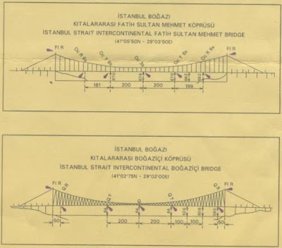
The bridges of Istanbul Bogazi

Location : Off Sardegna Island, Mediterian / 38 45 N / 005 23 E

Yesterday I had shown you a picture of one of the bridges connecting the
continents of Europe and Asia. To the bridge enthusiasts, who might find the
pictures of the bridges often enough, I wanted to show this information
about the bridges, given on the navigational charts. These are great bridges
and as we can see that the first bridge has a span of about 600 meters, the
second bridge, goes on for about a kilometer.

With a height of about 68 meters from the high water mark, these are some of
the greatest bridges that I have passed under.